Adding GeoJSON to a Mapbox Style
By @RobLabs
Add your own Geo Data
In previous posts we talked about Mapbox Styles and GeoJSON.
Now we want to put these two concepts together. Suppose we have a GeoJSON that contains points of interest in Flagstaff, Arizona. One of the features is the tallest peak in the Coconino National Forest.
{
  "type": "Feature",
  "properties": {
    "name": "Humphreys Peak"
  },
  "geometry": {
    "coordinates": [
      -111.677946,
      35.346362
    ],
    "type": "Point"
  }
}
Mapbox Studio
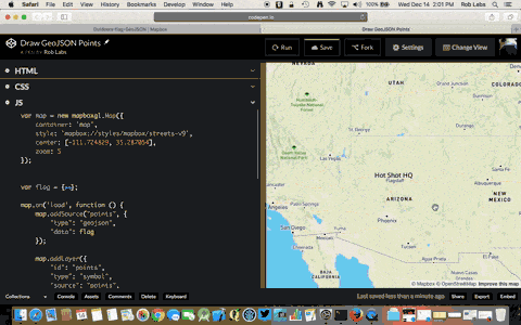
Steps to add this GeoJSON into Mapbox.com/studio and style this point feature directly in Studio.
- You can drag your GeoJSON directly into studio
- Navigate to Datasets and drag your GeoJSON directly into the Datasets view
- Once its uploaded, click on
Start editing - Look around the Datasets view and add any Points, LinesStrings or Polygons you want
- Save and export to a Tileset
- View the Tileset and click on
Add to Style - Choose an existing or new style
For example
- Add our Points as either a
Circleor aSymbol. Do this so you can see the difference between these two types - Be sure to access the properties of your data set. In our case we can access the Feature
name - Adjust properties for
Color,Halo colorandHalo widthto give a great label effect - See a live sample at CodePen.io/roblabs
See how it looks in
- Streets Mapbox Style
- Satellite + Streets Mapbox Style
- Outdoors Mapbox Style